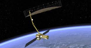
NASA and ISRO are gearing up to launch the NISAR (NASA-ISRO Synthetic Aperture Radar) satellite in early 2025. This cutting-edge satellite will provide unparalleled insights into Earth’s surface, tracking even minute changes across land, glaciers, ice sheets, and vegetation.
A joint venture between the Indian Space Research Organisation (ISRO) and NASA, NISAR is designed to measure Earth’s surface motions with incredible precision—down to fractions of an inch. Using advanced radar systems—L-band and S-band technologies developed by NASA and ISRO respectively—the satellite will map the planet’s land and ice-covered areas every 12 days.
What sets NISAR apart is its ability to collect data both day and night, even in challenging conditions like dense cloud cover or thick vegetation. While it cannot predict earthquakes, it will help identify high-risk seismic zones. For instance, researchers in California can use NISAR to monitor areas prone to earthquakes, and in the Himalayas, it will provide critical data on the region’s seismic hazards, which have historically seen major earthquakes.
The satellite will also aid volcano research by detecting land deformations that could precede eruptions, offering deeper insights into volcanic activity. Additionally, NISAR will monitor critical infrastructure such as levees, aqueducts, and dams to assess the impact of seismic activity.
According to Sreejith K M, ISRO’s solid Earth science lead for NISAR, the satellite will provide unprecedented information, particularly for the Himalayan plate boundary. “The area has a history of high-magnitude earthquakes, and NISAR will help us better understand the seismic hazards,” he said.
By tracking Earth’s surface with remarkable accuracy, NISAR promises to be a game-changer in monitoring natural disasters and understanding the dynamic changes shaping our planet.


